SPRUCE Bog Surface Elevation Assessments with SET Instrument Beginning in 2013
Description
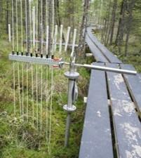
This data set reports plot-specific bog surface elevation measurements collected with the SPRUCE Elevation Transect (SET) instrument at the Spruce and Peatland Responses Under Changing Environments (SPRUCE) experimental site within the Marcell Experimental Forest in northern Minnesota, USA. The SET instrument is a modified version of the Cahoon et al. (2002) surface elevation table instrument. The device is mounted to fixed stands that are anchored in deep sediments, making it capable of identifying subtle changes in bog surface elevation over time. Measurements are reported as absolute elevation in meters above mean sea level (amsl) for two locations in each of the SPRUCE experimental treatment plots and additional ambient boardwalk plots: 4, 5, 6, 7, 8, 9, 10, 11, 13, 14, 15, 16, 17, 19, 20 and 21. Measurements were collected from June 2013 through September 2025 (2013-06-02 to 2025-09-08). Changes in bog surface elevation may indicate alterations in the carbon and water cycles due to changing environmental conditions. This data set contains one data file in comma separate (*.csv) format. Additional metadata are provided: one data dictionary and a file-level metadata file in comma separate (.csv) format and a user guide in PDF (*.pdf) format.
Citation
This dataset is available for download at ESS-DIVE, please visit the DOI link in the citation below for access.
Hanson, P.J., J.R. Phillips, M.P. Guilliams, D.J. Brice, L.A. Hook, and M.A. Mayes. 2018. SPRUCE Bog Surface Elevation Assessments with SPRUCE Elevation Transect Instrument, Marcell Experimental Forest, Minnesota, 2013-2025. ORNL Terrestrial Ecosystem Science SFA, ESS-DIVE repository. Dataset. https://doi.org/10.25581/spruce.055/1455014.
Posted
Wednesday, June 20, 2018
SPRUCE ID: spruce.055
Public
Click image to see full-sized version