SPRUCE Plot-Level Water Table Data Assessments for Absolute Elevations and Height with Respect to Mean Hollows Beginning in 2015
Description
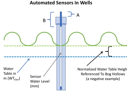
This data set provides a record of the half-hourly automated water table depth data collected for 12 SPRUCE plots (4, 6, 7, 8, 10, 11, 13, 14, 16, 17, 19, 20, and 21) beginning during deep peat heating (DPH) in 2015 and continuing throughout the whole ecosystem warming (WEW) manipulations for the SPRUCE Project (Hanson et al. 2017). The data currently cover 2015-05-12 through 2024-12-31 and will be updated periodically throughout the duration of the SPRUCE project.
Also provided are daily plot normalized data for water table depths with respect to mean hollow locations within each plot. The hollow referenced data provide the basis for the intercomparison of peat saturation or aeration across treatment plots.
A limited data set for manual water table observations made periodically from 2015-2022 are also provided as a reference to the plot center automated observations.
In August 2015, WEW was initiated at 5 warming levels (+0, +2. +4.5, +6.75 and +9 °C) with 2 plots per warming level. DPH measurements were underway before the initiation of WEW heating treatments and both are expected to operate through 2025. Elevated CO2 treatments were added in June 2016 (Enclosures 4, 10, 11, 16 and 19). All measurements were made at the 8.1-ha S1 bog forest site in northern Minnesota, 40 km north of Grand Rapids, in the USDA Forest Service Marcell Experimental Forest (MEF).
This dataset contains three data files in comma separated (*.csv) format.
Citation
Hanson, P.J., Phillips, J.R., Nettles, W.R., Pearson, K.J., Hook, L.A. 2020. SPRUCE Plot-Level Water Table Data Assessments for Absolute Elevations and Height with Respect to Mean Hollows Beginning in 2015. Oak Ridge National Laboratory, TES SFA, U.S. Department of Energy, Oak Ridge, Tennessee, U.S.A. https://doi.org/10.25581/spruce.079/1608615
Download
Posted
Tuesday, April 7, 2020
SPRUCE ID: spruce.079
Public
Click image to see full-sized version